The Hornyhead Branch Restoration and Habitat Enhancement Project was a cooperative project of the Cumberland Mountain Resource Conservation and Development Association, Emory River Watershed Association, Morgan County Soil Conservation District, Tennessee Department of Agriculture, Tennessee Valley Authority, University of Tennessee Forest Resources Research and Education Center, and the USDA-Natural Resource Conservation Service. Funding was provided by the National Fish and Wildlife Foundation, Tennessee Valley Authority, and the Morgan County Soil Conservation District.
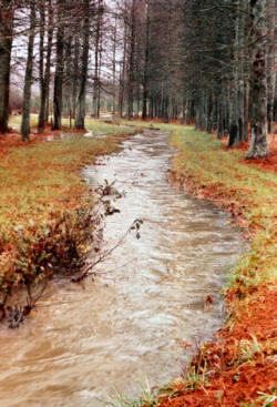
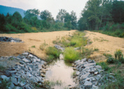
The Hornyhead Branch is a tributary to Crooked Fork Creek, a creek listed on Tennessee’s Impaired Waters List for siltation, habitat alteration, and nutrient enrichment. These conditions exist due to historic bench mining, channelization, three permitted discharges, and agricultural practices. Hornyhead echoes the problems facing Crooked Fork. This creek drains roughly 1.04 sq miles of strip mined mountain land (Little Brushy Mountain) as it flows off the UT Cumberland Forest Unit property. It has been channelized and continues to be affected by agricultural practices both above and down stream of the UT property.
The objectives of the project were to:
- Improve and stabilize the banks of Hornyhead Branch
- Demonstrate various methods of streambank restoration
- Raise the water quality of this tributary of Crooked Fork Creek
- Use this project for continuing education of stream restoration techniques for resource managers and landowners
- Establish and foster cooperation with other agencies in riparian zone management.
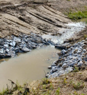
V-wiers provide grade control, keep the thalweg in the center of the channel, and protect streambanks from erosion. They also improve in-stream habitat by creating scour pools and by providing oxygen and cover. Orient arms of the V upstream at 20- to 30-degree angles off the bank. Slope the arms to the point at 2-20% the longer and flatter the structures, the more the streambank is protected and habitat enhanced. The “V” always points upstream with the point setting the grade of the streambed.
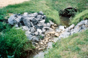
A rock jetty follows the detail of a V-weir but consists of only one arm extending from the bank to the thalweg. While protecting the connected bank and improving in-stream habitat, rock jetty’s are limited in grade control.
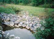
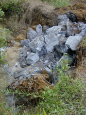
Rock riprap, properly designed and placed, is an effective method of streambank protection and provides long-term stability even in high-velocity flow conditions. Cost can be prohibitive for large sections and the necessary removal of streambed materials tends to limit aquatic habitat.
Same as bankfull height except minimizing rock and thereby reducing overall cost as well as allowing for use of vegetation producing streamside habitat.
Root wads armor a streambank by deflecting stream flows away from the bank. They also support the streambank structurally, provide habitat for fish and other aquatic animals and supply food for aquatic insects. Install root wads at the toe of the bank, as low as possible. Where scour depths are high, place footer logs below the root wad. Rock and vegetation prevent back-eddy scour that may be caused by root wad during high flow.
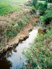
Cedar trees stabilize eroding banks, add roughness to the stream channel capturing silt and providing aquatic habitat. Increases the potential for capturing fine particulate organic matter, food for many benthic (bottom-dwelling) organisms. Anchor a row of 6 feet long cedar trees along the bank toe. A second row may be installed if necessary as a cost effective method of streambank stabilization and aquatic habitat improvement.
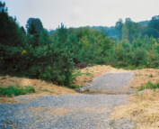
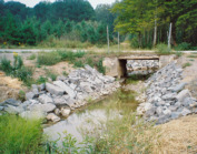
Crossings should minimize negative impacts on stream stability, sediment transport, aquatic habitat and fish passage while meeting prescribed hydraulic and structural criteria. Fords should have a solid bottom. A ford can be created by excavating soil from the stream bottom and banks then backfilling with gravel over geotextile fabric. This establishes a smooth hard surface for a low water crossing. Material should not significantly impede stream flow or release significant amounts of fine material into the stream.
The purpose of revegetating disturbed areas is to reduce soil erosion. It is important to apply a proper seeding mix of “temporary” and “permanent” seed mixtures. Fertilization and liming are often crucial in promoting growth on disturbed sites. “Greening” bare soil also has a significant aesthetic appeal. The addition of woody vegetation along the streambank is critical to improving overall water quality and stream habitat. Streams and riparian vegetation interaction include the effects of leaf litter and plant material on carbon influx, shading, bank integrity, channel shape, seasonal changes in water quality and flow, nutrient cycling, productivity, and pollution abatement.